Erick Strengthens Into Hurricane, Threatens Mexico With Torrential Rain and Coastal Hazards
The clock is ticking for southern Mexico as Hurricane Erick barrels toward the coast, packing powerful winds, dangerous surf, and enough rain to trigger deadly floods and landslides overnight.

Hurricane Erick is quickly strengthening in the eastern Pacific and is set to bring a trio of threats to southern Mexico: damaging winds, life-threatening flash flooding, and dangerous coastal conditions. The storm is expected to make landfall early Thursday, but its impacts will begin well before that.
JUST IN: #Erick is now a Category 1 Hurricane, attaining winds of 75 mph (120 kph) and a core pressure of 991 mbar. Super-cold convection continues to proliferate throughout the CDO, and with expansive outflow, deep moisture layers, and very warm water temperatures ahead, Erick pic.twitter.com/okf4fM2QZf
— Backpirch Weather (@BackpirchCrew) June 18, 2025
As of this morning, Erick is located about 160 miles south-southeast of Puerto Ángel and moving northwest at 7 mph. Maximum sustained winds have reached 75 mph, making it a Category 1 hurricane, and further strengthening is likely — possibly rapidly — before landfall.
A Closer Look at the Threats
Satellite data shows Erick becoming more organized, with thunderstorms tightening around its center — a classic sign that it’s gaining power. The environment ahead is nearly perfect for intensification, and some models suggest Erick could reach major hurricane strength in the next 24 to 36 hours.

The storm is expected to make landfall along Mexico’s southern Pacific coast, likely somewhere in Oaxaca, during the early hours of Thursday. However, tropical-storm-force winds will arrive much sooner, making Wednesday evening the critical window to finish preparations.
What to Expect
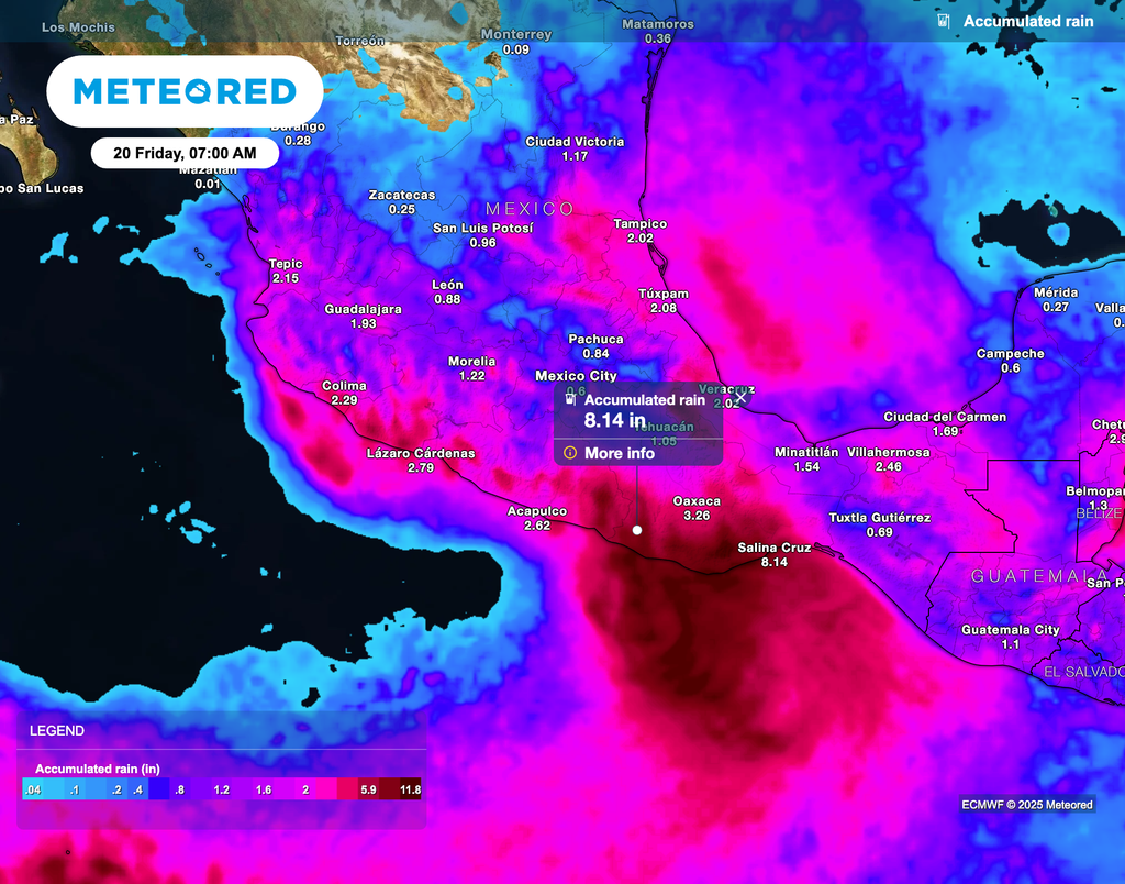
Torrential Rain: Erick could unload 8 to 16 inches of rain in Oaxaca and Guerrero, with isolated spots getting up to 20 inches. That much rain in mountainous terrain could lead to life-threatening flash floods and landslides. Lighter, but still hazardous, amounts of 3 to 8 inches are possible in Chiapas, Michoacán, Colima, and Jalisco.

Strong Winds: Hurricane-force winds are likely to arrive overnight tonight into early Thursday, with tropical storm conditions setting in earlier. Power outages and wind damage are possible, especially near the coast.
Storm Surge and High Surf: Dangerous coastal flooding is expected, especially near and just east of where the center of the storm comes ashore. Large, damaging waves and life-threatening rip currents will begin affecting southern Mexico’s beaches later today.
Summary of Watches and Warnings in Effect
A Hurricane Warning is in effect from Acapulco to Puerto Ángel, where hurricane conditions are expected, and preparations to protect life and property should be rushed to completion. A Hurricane Watch has been issued for areas west of Acapulco to Tecpan de Galeana, and east of Puerto Ángel to Bahías de Huatulco, meaning hurricane conditions are possible within the next 48 hours.
Meanwhile, a Tropical Storm Warning is in place east of Puerto Ángel to Salina Cruz, where tropical storm conditions are expected within 36 hours.


