Tropical Storm Alvin Kicks Off 2025 Pacific Hurricane Season — Another Disturbance on the Horizon
The Pacific hurricane season is wasting no time. Just days into the official start, Tropical Storm Alvin has spun to life off the coast of southwestern Mexico—churning up dangerous surf and signaling that the season may be off to an active start. And Alvin might not be alone for long.

The 2025 Pacific hurricane season has officially begun, and it’s already making waves—literally. The first system of the season, Tropical Storm Alvin, formed earlier this week in the eastern Pacific Ocean and quickly strengthened into a tropical storm. While Alvin is staying well offshore, it’s still having an impact on parts of western Mexico and the Baja California Peninsula, and it’s not the only system meteorologists are watching.
Tropical Storm Alvin: What You Need to Know
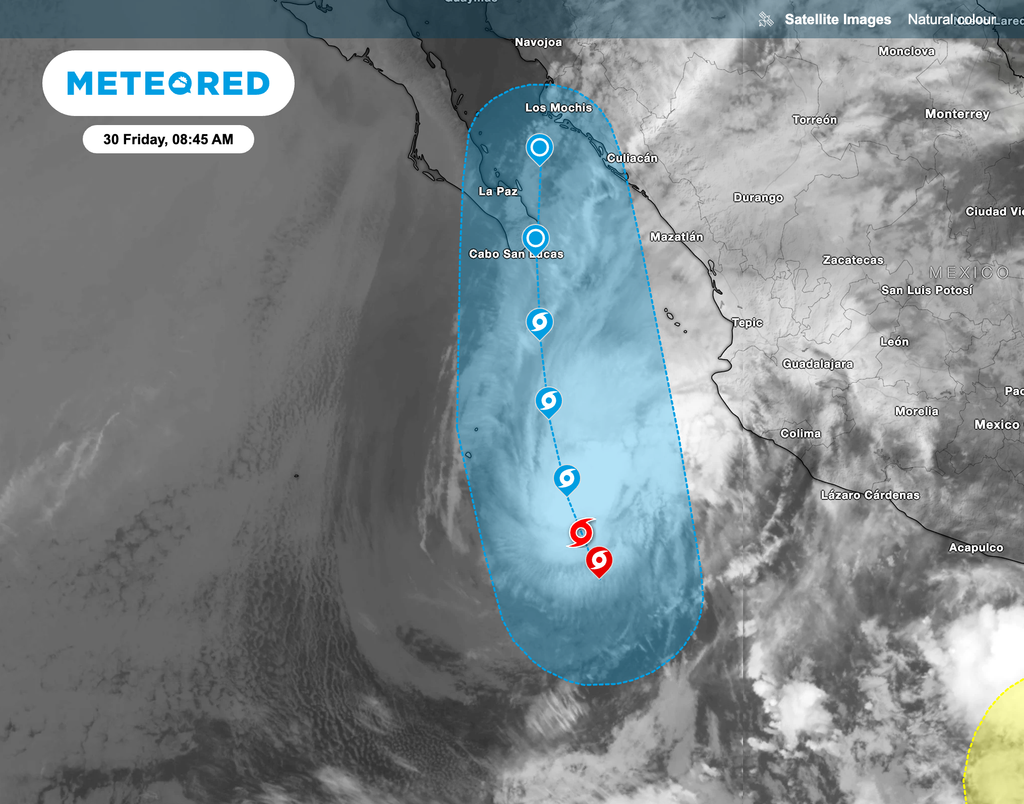
As of early Friday morning, the National Hurricane Center (NHC) placed the center of Tropical Storm Alvin about 455 miles south-southeast of the southern tip of Baja California, moving north-northwest at about 10 mph (17 km/h). Maximum sustained winds have dropped to 50 mph (85 km/h), with higher gusts still possible.
The storm is weakening, thanks to strong vertical wind shear—which disrupts the storm’s internal structure—and cooler sea surface temperatures. Alvin is no longer strengthening and is expected to gradually lose steam over the next couple of days. According to the NHC, it could become a post-tropical remnant low by Saturday.
5/29 - Tropical Storm #ALVIN continues to strengthen in the EPAC - sustained winds now at 50 kt, gusts to 60 kt.
— NHC_TAFB (@NHC_TAFB) May 29, 2025
Seas near the center around 4 m, building to 5 m tonight into early Friday.
More info at https://t.co/26J6Uogt6o #GOESWest #Mexico #tropicalstorm #seas pic.twitter.com/0ay9697gmE
Despite its weakening trend, Alvin remains a large system. Tropical-storm-force winds extend outward up to 140 miles (220 km) from the center. The storm is also generating large ocean swells, which are pushing toward the Mexican coastline.

These swells will affect west-central and southwestern Mexico as well as the southern Baja California Peninsula, producing rough surf, beach erosion, and dangerous rip currents. Even though Alvin is staying out to sea, coastal communities should remain cautious, especially through the weekend.
Another Disturbance May Develop Next Week
While Alvin begins to wind down, forecasters are turning their attention to a new potential area of tropical development in the coming days.

According to the NHC, a broad area of low pressure may form off the coast of Central America and southern Mexico by the middle of next week. Conditions in the atmosphere and ocean could become more favorable for development as this system moves generally west to west-northwest at 10 to 15 mph.
At the moment, this disturbance has only a low chance of development:
-
Near 0% chance of formation in the next 48 hours.
-
20% chance of formation in the next 7 days.
Key Takeaways
-
Tropical Storm Alvin is the first named storm of the 2025 Pacific hurricane season. It’s weakening and expected to become a remnant low by Saturday.
-
Despite staying offshore, Alvin is sending dangerous swells and surf toward western Mexico and Baja California. Beachgoers should be cautious.
-
Another disturbance could form next week off the coast of Central America and southern Mexico, but development chances remain low for now.
Stay tuned for updates from the National Hurricane Center, and if you’re along the coast, pay close attention to local advisories—especially if you're planning to be near the water. Tropical systems don’t have to make landfall to cause problems.


